
Ride With GPS is a full service cycling site that allows you to map rides, upload and analyze ride data, and compare efforts with friends. Or, as a screenwriter might pitch it, it’s MayMyRide meets Training Peaks meets Strava meets Pretty Lady, with a hooker with a heart of gold and a twist at the end that you’ll never see coming. Ok, maybe just the first three parts, but there is one thing it does that no other site can do, and it’ll blow your mind.
RWGPS was started in 2007 by Zack Ham and Cullen King as a route planner and has evolved over the years to its present state. The two have persisted without accepting any outside funding, and have grown the site to the point where it’s both their day jobs. The duo are very accessible – a friend and I have both suggested features and helped debug, and their response rate is excellent. Most of the site’s features are free, with advanced features available at two premium levels.
Mapping
Creating a route is dead simple – just click along your route to draw. Compared to Map My Ride, the elevation plot is bigger and more detailed, and renders way faster (apparently this was a coding coup). I could’ve really used this feature on my recent trip to California where I kept plotting rides shorter than the free time I had for that day. Knowing the distance and elevation gain in advance would’ve really helped maximize my daily liberty from parenting. Once created the route can be uploaded to a Garmin or printed out as cue sheets, which are highly customizable.
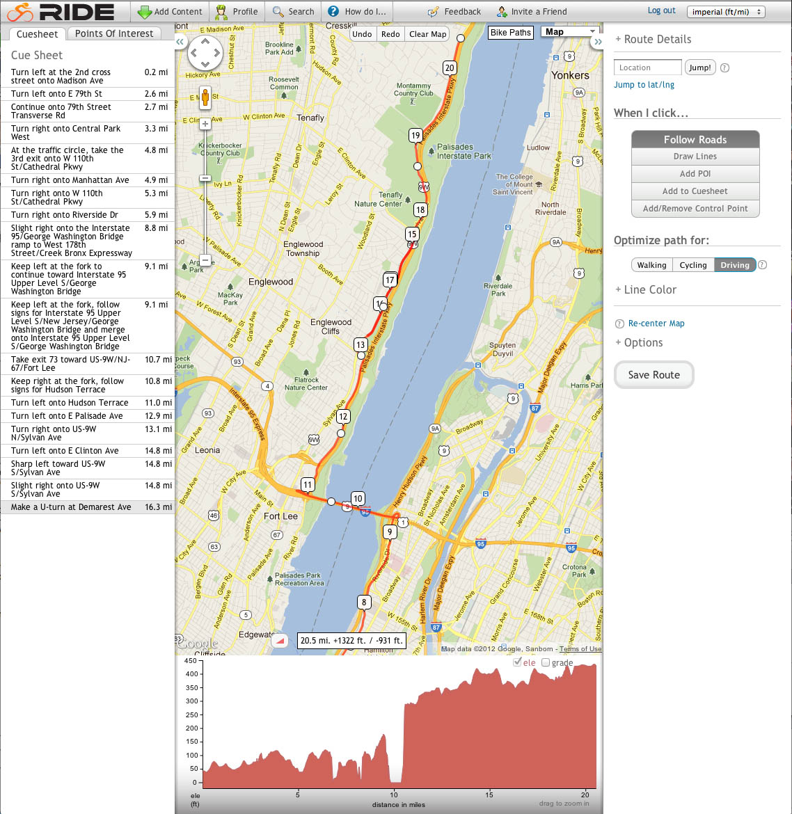
Right click on screen grabs for full view.
Analysis
Many tasks in RWGPS seem elegantly coded, as they occur at lightning speed. This is the case with ride uploads, which are incredibly quick and painless. Once uploaded, enter ‘detailed view’, click on the ‘metrics’ tab and you’re in ride analysis. This ride is here if you want to poke around the file yourself.
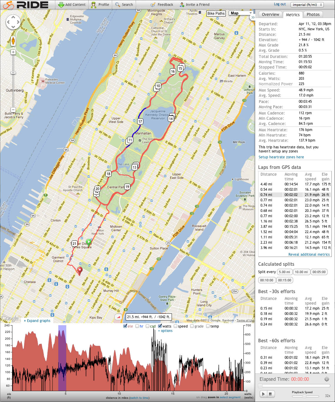
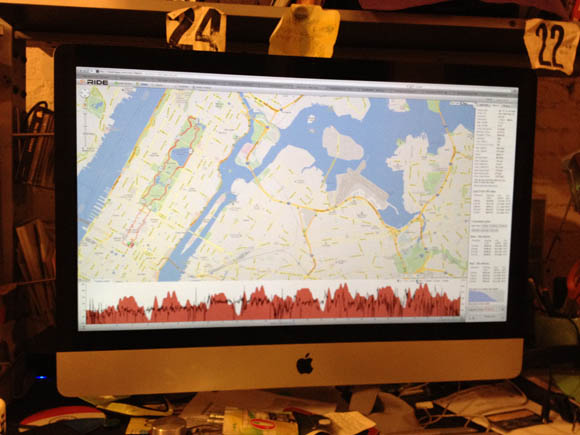
The basic view is a map with an elevation plot below. You can choose to overlay other graphs onto the elevation plot, here I’ve chosen to show power. All the metrics are visible at the right, and when you mouse over an interval it’s highlighted on the map and the graph. You can also drag on the graph to zoom in.
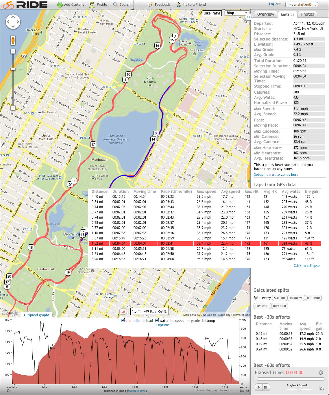
Click on a lap and both the map and graph zoom in. The metrics at the upper right also change to reflect the selected lap instead of the entire ride. Those changed numbers are shown on grey. You can also expand the laps box to show all the metrics for all the laps.
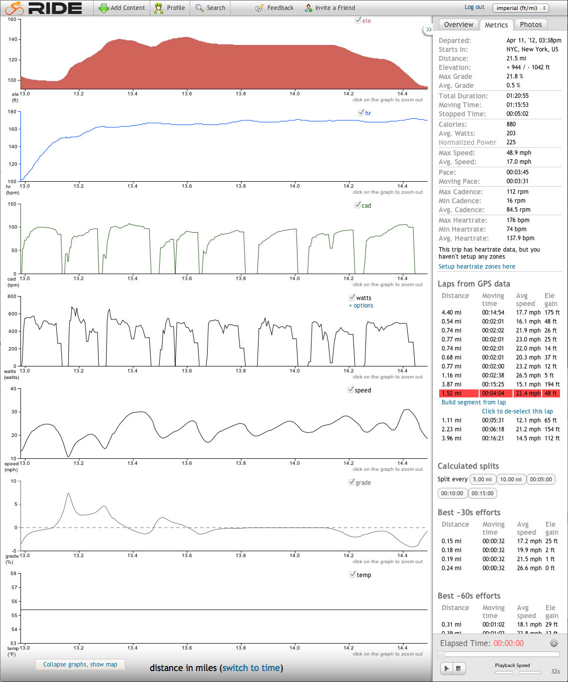
If maps aren’t your thing you can expand the graphs and see them in a stacked view. One of my favorite things about RWGPS is that it expands to fill your browser window. If I were a buzzword wielding douche I’d say that fhe gorgeous full screen view really lets me drill down into my data. Here it is in its full screen glory on my messy desk.
For now, analysis in RWGPS lacks long term metrics, but they’re in the works.
Social
Like Strava, you can create and save segments of your ride and compare your efforts with others. Here’s the leaderboard for a lap of Central Park beginning and ending at Cat’s Paw, the traditional start/finish for Central Park races. For now RWGPS doesn’t have the massive community that Strava does (Ted King Strava’d Paris Roubaix, fer cryin’ out loud!), but I revel in the fact that I can podium a leaderboard before everyone catches on. You can create races and events, and coaches can make groups to monitor clients’ training.
…and finally, THE COOLEST THING EVER…
Go back to that Central Park leaderboard and select some rides. Click on ‘compare efforts’, then ‘race efforts’, hit the play button, and you’ll see those riders race the course. I made a video of the first lap of the 4/14 Spring Series masters race, comparing my file and Schmalz’s Strava file. I’m the green dot, Schmalz is blue. You might want to go full screen and 720p to see things clearly.
Dan was in a move at the Northern tip of the loop that got very little separation, but set the table for six riders to go clear coming down the west side (if one of you guys have a ride file from that race, sign up and let me know!). You can even see Dan drop back in the pack momentarily as we head south. I attacked near the 79th street Transverse and bridged to the breakaway. Now, imagine if many people uploaded their files in a point to point race (it’s hard to make a segment made of mulitple laps of the same course, so you can’t see a circuit race from beginning to end). You’d be able to see the race played out in breakaways and counterattacks! How cool would that be!
So go on, sign up with a free account and try it out. Get your friends to sign up and you’ll be able to relive the next race you enter together. But it doesn’t just have to be future races. Anyone want to recreate Battenkill?
Great review.
Ride With GPS is one of those small bootstrapped startups who have better features and faster response times to feature requests and bugs, but yet can’t seem to take on a giant with much better funding. (Strava).
Strava is loaded with VC money. As a result their growth has been huge. But having been a Strava user for a while, it’s buggy as hell and getting anyone to recognize your bugs, let alone fix them, is impossible.
Here’s my favorite bug: http://app.strava.com/segments/834984 Unless we were all on motorbikes, I doubt anyone was going that fast.. That bug has existed for close to 8 months.
Ride With GPS on the other hand is the complete opposite. Zack and Cullen are incredibly fast with getting feature requests put in a bugs fixed. As a result, their site is easily the best there is in this space.
You really owe it yourself to try them for a few weeks.
Our growth over the past year has been pretty huge — we just don’t have a rocket strapped to our backs. There are certainly social aspects to a cycling site that benefit from a critical mass of users, but most of what we do – planning rides, managing a training log, analyzing your data – works great whether you’re one of 10 users or one of 10 million.
Let me know if you have any questions, you can reach me directly at zack@ridewithgps.com
Thanks!
The video needs a soundtrack, perhaps this: http://www.youtube.com/watch?v=0hhm0NHhCBg
I’m interested, I’ll have to give this a try today!
I’ll upload Battenkill tonight. Cat3 Pink.
Battenkill Cat 3 Pink uploaded
I don’t know what I’d do with all this information. I may have to cut back on riding to keep up.
Now I have to use Strava and this, but can see myself moving towards Ride with GPS as it get more popular.
I haven’t had a computer on my bike in years. HR and Time is all I got. If I get a computer and connect with Ride GPS is power data also able to be included? I would need a power meter as well though.
Vincent,
If you have a power meter we’ll let you graph the power data, as well as 30/60 second moving averages. We’ll show your best efforts as well and you can interact with them. Cullen and I have power meters now and are almost done with something that will show you your performance across any number of your rides (best 20 min efforts from all rides this year by week, that kind of stuff).
Thanks,
Zack (zack@ridewithgps.com)
Now after my ride I have to download to Golden Cheetah and upload to Strava, Training Peaks, and RWGPS
This is gonna be great for my sex life!
I’m not taking no blame for no dry spells. That’s on you.
URL to your ride, amcgee? I’ll try to get some of our BH guys to upload theirs.
http://ridewithgps.com/trips/611152
are they developing an android app?…couldn’t find one. I don’t have a Garmin but use Strava (or RunKeeper) on my phone. I like that you don’t have to buy a specific device.
how do that function to see other racers on the ride?
Sometimes i get lost riding around in circles in central park. What should i do?
Battenkill segment loaded. Try it out:
http://ridewithgps.com/segments/Battenkill
Just realized that the DA/Andrew McGee comparison isn’t the most interesting, as they were separated by 1 second!
http://ridewithgps.com/routes/1119837
I do agree that the ride with the GPS is more safe for the riders. These GPS tracking devices will help them to be in the loop of the security forces and to help them to be located in the case of an emergency. windows 8 problems